Map Tile API
Generate signed URLs for map tiles and basemap data. Use with MapLibre or Leaflet to render interactive maps showing customer locations and stores.
Mapping Concepts
There are several key concepts that are important to understand when implementing a map using this API:- Signed URL: a secure URL generated for a specific session within a limited time period, with limited permissions. This contains authentication information within the query, thus reducing the time required to authenticate and reducing overall response times. You will receive two signed URLs, one for vector based tiles and another for raster based tiles
- Basemap data: basemaps form the foundation for your map, providing geographic context stored as tile layers. These layers include the context required to display useful information such as the names of streets, buildings and land categorisation
- Vector tiles: a format of tile that stores map data using vector shapes. As these are composed dynamically, they can be easily styled and smoothly zoom in and out as a user is navigating. These are generally faster to load than Raster tiles, but can be more demanding on the end user’s hardware
- Raster tiles: a format of tile that stores map data using grids of pixels, commonly as images. These tiles can be slower to load than vector tiles, but are generally less demanding on the end user’s hardware
- Map Style: a Map style is a JSON document that defines how the map will appear when rendered
- Map renderer: library required to render a map within an application. Once you have defined your data source as the signed URL you receive from this API, the map rendering library will pull data from Loqate at run time, rendering the map data for you. Commonly used open source libraries for this include MapLibre, Leaflet and Amplify
Application flow using a map renderer
Signed URLs can be used to request individual map tiles if required, however for more complex applications you’re likely to use a map renderer. The following diagram represents how an application could be designed to work with our API and a map renderer: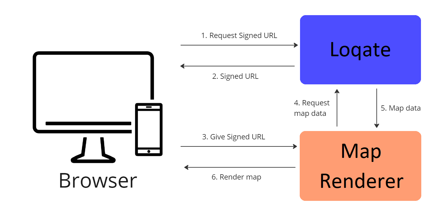
- Make a request to https://api.addressy.com/LocationServices/Mapping/GetUrl/v1.00/json4.ws?key={{license_key}} (adding in your own API key)
- Receive multiple Signed URLs in the response (one for Raster tiles and one for Vector tiles)
- Choose whether you want to use Raster tiles or Vector tiles, and pass the appropriate Signed URL to the map renderer
- The map renderer will request basemap data from Loqate as needed (for instance this could be when a user scrolls on your map and the renderer interprets which tiles will be needed next)
- Loqate will return the appropriate map data
- The map renderer will then use this data to render the map on the screen of your browser
Attribution Statement
Attribution Statement
Authorizations
Body
Response
Success
Signed URL to use when wanting to render Vector tiles, valid for one hour after creation. This URL contains all the information required by a map renderer to draw the layers of data for the final map. Vector tiles offer more flexibility with styling and improved performance when navigating the map but they can be more demanding on end user hardware.
Signed URL to use when wanting to render Raster tiles, valid for one hour after creation. This will give you no flexibility over styling options and can be slower to load but is generally less demanding on end user hardware.
UTC Timestamp representing when the URLs were signed and generated.