- Houses, bungalows and flats covered although the majority of testing has been on freehold properties i.e. typically houses and bungalows;
- England and Wales full coverage;
- Scotland full coverage but reduced accuracy because of different policies for land and property registration and the publication of data;
- Northern Ireland limited coverage, just includes estate agent data;
- Isle of Man and Channel Islands not covered;
Database Fields
Utility fields
The database contains a set of utility fields and a set of feature fields. The utility fields are as follows:- UPRN - the Unique Property Reference Number originating from the Ordnance Survey
- UDPRN - the Unique Delivery Point Reference Number originating from the Royal Mail
- UMRRN - the Unique Multiple Residence Reference Number originating from the Royal Mail
- Address1 - a standardised first line of address containing house name or number and street
- Postcode - a full postcode
- Easting - Ordnance Survey National Grid Easting
- Northing - Ordnance Survey National Grid Northing
- Latitude - latitude in ETRS89 converted from the easting using OSTN02
- Longitude - longitude in ETRS89 converted from the northing using OSTN02
- Output area code - Census 2011 Output Area (OA) code from the ONS Postcode Directory
- Lower super output area code - Census 2011 Lower Super Output Area (LSOA) code from the ONS Postcode Directory
- Output area code - Census 2021 Output Area (OA) code from the ONS Postcode Directory
- Lower super output area code - Census 2021 Lower Super Output Area (LSOA) code from the ONS Postcode Directory
- Country - one of England, Northern Ireland, Scotland, or Wales from the ONS Postcode Directory
Data items
The feature fields in the database are arranged in sets of three:- X - this is the data item of interest, for example a number of bedrooms for which X = “bedrooms”;
- source_X - this is the source of the information, for example the number 2 indicates that this data item is sourced from the Land Registry;
- p_X - this is a confidence score for the data ranging between 0 and 1. Confidence scores are calculated, where possible, as a “fraction correct” measure against a groundtruth dataset of 36,000 properties supplied by Simple and Open;
- Property type - whether the property is semi-detached, detached, terraced or a flat
- Number of floors - the estimated number of floors in the property based on the height of the building.
- Number of bedrooms - the number of bedrooms in a property
- Number of bathrooms - the number of bathrooms in a property
- Number of rooms in total - the number of rooms excluding bathrooms and kitchens
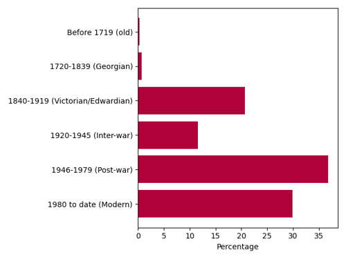
- Building construction period - the construction date of a building in one of the following periods: (before 1719 (old), 1720-1839 (Georgian), 1840-1919 (Victorian/Edwardian), 1920-1945 (Inter-war), 1946-1979 (Post-war) and 1980 to date (Modern))
- Year built - the year built, only available for those buildings in the Land Registry Price Paid data, built after 1995
- Listed building - The grade of listing of a building, if it is listed, using data supplied by English Heritage, Cadw or Historic Scotland
- Cadastral polygon area - the area of the cadastral parcel in which the building sits expressed in square metres using data from Land Registry
- Height - the building height in metres
- Building footprint (square metres) - the approximate footprint of the building expressed in square metres
- Building volume (cubic metres) - the approximate volume of the building expressed in cubic metres
- Average roof slope - the average slope of the property roof, can be used to identify properties with flat roofs
- Flat roof fraction - the estimated fraction of a building which has a flat roof
- Distance to tree - distance from the nearest tree over 10 metres tall to the property geocode
- Geocode multiplicity - the number of property geocodes falling within the footprint of the building at 1.8 metres above ground level
- Floor area (square metres) - the liveable floor area in square metres
- Last transaction price - the price paid at the last transaction recorded by the Land Registry (England and Wales only, back to 1995)
- Last transaction date - the date of the last transaction recorded by the Land Registry (England and Wales only, back to 1995)
- Last transaction duration type - the duration type of the last transaction recorded by the Land Registry (England and Wales only, back to 1995)
- Estimated current value - estimated current value based on data from Land Registry (England and Wales only, back to 1995)
- Number of transactions - the number of transactions recorded by the Land Registry (England and Wales only, back to 1995)
- Estimated council tax band - estimated council tax from price at reference years using Land Registry data (England and Wales only, back to 1995)
- Within 200 metres of watercourse - flag indicating whether there is a watercourse within 200 metres
- Distance to watercourse (within 200 metres) - distance (in metres) to a watercourse, if it is within 200 metres
- Distance to road - the distance to the centre line of the nearest road from the property geocode, not necessarily accessible
- Road class - road class, as provided by Ordnance Survey
- Business usage - a flag indicating potential business usage
- Planning classification - planning classification as per Town and Country Planning (Use Classes) Order 1987 for non-domestic properties
- Congestion zone - a flag indicating if a property is in the London Congestion Zone
- Burglary rate - the number of burglaries per property per year averaged over a LSOA (England and Wales only)
- Storey on which flat sits - storey on which a flat sits. This typically contains N/A where it is not available or applicable or a number which may have been derived from a model based on the text found in the original data source
- Is top floor flat? - Is a flat on the top floor of the building
- Number of extensions - the number of extensions to a property, typically 1 but up to 4
- Wall type - the type of wall used in construction, possible values cavity wall, solid brick, sandstone, granite, timber frame, system built and SAP05
- Main central heating fuel - Main central heating fuel, possible values include gas, electricity, oil, coal, LPG, wood, B30K (a biofuel mix) and also ‘not known’ and ‘none’
- Type of tenure - type of tenure: owner-occupier, rented or social housing
- Energy rating - Energy rating as indicated in the EPC Energy Certificate
- EPC Inspection Date - Inspection date indicated in the EPC Energy Certificate
- Multi-residential property - a flag to identify properties that are multi-residential
Technical details
Technical details for each of these fields are shown in the table below:
Table 1: Technical details for each utility and data field. Lookup fields contain positive integers (starting from zero). source_X fields are lookup fields, p_X fields are number fields.
Lookup tables
Tables 2-13 are the lookup tables relating the numbers found in the database fields to descriptions for the property type, property age, Council Tax band, and data source. The Yes/No lookup is used for the ‘watercourse 200M’, ‘congestion zone’ and ‘top floor flat’ fields.Yes/no lookup
Table 2: Yes/no lookup
Property type lookup
Table 3: Property type lookup
Property age lookup
Table 4: Property age lookup
Council Tax lookup
Table 5: Council tax band lookup
Data source lookup
Table 6: Data source lookup
Business usage lookup
Table 7: Business usage lookup
Main fuel lookup
Table 8: Main fuel lookup
Wall type lookup
Table 9: Wall type lookup
Planning classification lookup
Table 10: Planning classification lookup
Road class lookup
Table 11: Road class lookup
Listed building grade lookup
Table 12: Listed building grade lookup
Tenure lookup
Table 13: Tenure lookup
Energy rating lookup
Table 14: Energy rating lookup
Last transaction duration type lookup
Table 15: Last transaction duration type lookup
Multi-residential lookup
Table 16: Last transaction duration type lookup
Accuracy
Accuracy for the tested fields calculated using 2025-02_groundtruth on 2025-03-13 00:52:51 against 32233 properties is shown in the table below.
Table 17: Summary accuracy for fields, measured against ‘groundtruth’ properties in England and Wales, excluding flats
Coverage
The following tables show dataset coverage and accuracy for number of floors, bedrooms, age and property type using the along with confidence for these attributes based on measurements against the 33,000 property groundtruth dataset covering England and Wales.
Table 18: Accuracy and coverage for bedrooms
Table 19: Accuracy and coverage for bathrooms
Table 20: Accuracy and coverage for age
Table 21: Accuracy and coverage for property_type
Table 22: Accuracy and coverage for floors
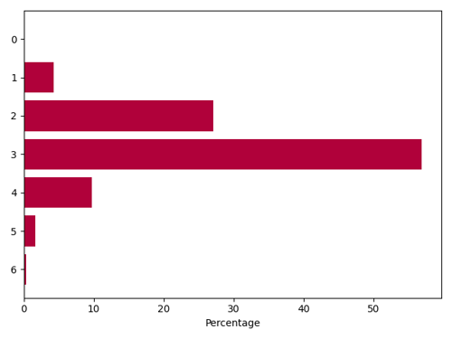
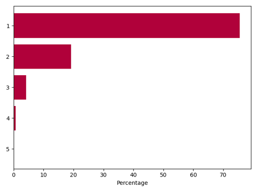
Attribute distribution charts
The following charts show the distribution of values for selected fields, for domestic properties, not arising from the default model.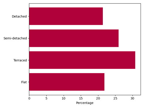
Direct data content
The following tables shows the coverage with direct data for the five fields tested against groundtruth.
Table 23: Percentage of data supplied from direct sources rather than modelled
Data recency
Data recency for the Property Intelligence dataset is determined by a number of factors, listed below:- The build process for Property Intelligence takes approximately 2 months from start to delivery to customer with quarterly scheduled releases;
- Individual datasets have a range of update frequencies, some are static and will never be updated, others are yearly, quarterly or monthly;
- Two datasets, EPC (formerly DCLG) and Estate agent data, have property-level fields which indicate when an inspection was carried out so potentially day-level data on recency could be provided;
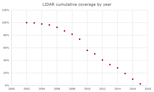
- The LIDAR data is a composite dataset, 80% of which has been collected in the last 10 years;
Table 24: Data recency and frequency by dataset
The Environment Agency started to systematically cover England for LIDAR measurement in about 2005 and they have added, very approximately 5% coverage in each year since then.
Attributions
This dataset contains Open Data typically provided under the UK government’s OGL3 license, a requirement of this license is that an attribution is provided for the data. These are as follows:- EPC: Contains public sector information licensed under the Open Government Licence v3.0.
- EPC Scotland: Contains public sector information licensed under the Open Government Licence v3.0.
- LIDAR - Environment Agency: (c) Environment Agency copyright and/or database right (2019). All rights reserved.
- LIDAR - Scottish Government: Crown copyright Scottish Government, SEPA and Scottish Water (2012)
- LIDAR - Lle: Contains Natural Resources Wales information © Natural Resource Wales and Database Right. All rights Reserved
- Land Registry Price Paid: Contains HM Land Registry data © Crown copyright and database right 2025. This data is licensed under the Open Government Licence v3.0.
- Land Registry INSPIRE Polygons: This information is subject to Crown copyright and database rights [2025] and is reproduced with the permission of HM Land Registry. The polygons (including the associated geometry, namely x, y co-ordinates) are subject to Crown copyright and database rights [2025] Ordnance Survey 100026316.
- Listed buildings England: Historic England (2025). Contains Ordnance Survey data © Crown copyright and database right (2025). The Historic England GIS Data contained in this material was obtained on 2024
- Listed buildings Wales: Designated Historic Asset Descriptive Information, The Welsh Historic Environment Service (Cadw), 2025, licensed under the Open Government Licence http://www.nationalarchives.gov.uk/doc/open-government-licence/version/3/
- Listed buildings Scotland: Contains Historic Environment Scotland and Ordnance Survey data © Historic Environment Scotland - Scottish Charity No. SC045925 © Crown copyright and database right [2025]
- Office for National Statistics: Source: Office for National Statistics licensed under the Open Government Licence v.3.0
- Office for National Statistics: Contains Royal Mail data © Royal Mail copyright and database right [2025]
- Office for National Statistics: Contains OS data © Crown copyright and database right [2025]
- Office for National Statistics: Contains GeoPlace data © Local Government Information House Limited copyright and database right [2025] [100050727]
- Ordnance Survey: Contains OS data © Crown copyright and database right (2025)
- Transport for London: Powered by TfL Open Data. Contains OS data © Crown copyright and database rights 2016 and Geomni UK Map data © and database rights [2019]
Release notes
September 2025
No new fields have been added in this release but sources have been updated.August 2025
No new fields have been added in this release but sources have been updated.July 2025
No new fields have been added in this release but sources have been updated.June 2025
No new fields have been added in this release but sources have been updated.May 2025
No new fields have been added in this release but sources have been updated.April 2025
No new fields have been added in this release but sources have been updated.March 2025
No new fields have been added in this release but sources have been updated.February 2025
No new fields have been added in this release but sources have been updated.January 2025
No new fields have been added in this release but sources have been updated.December 2024
No new fields have been added in this release but sources have been updated.November 2024
No new fields have been added in this release but sources have been updated.October 2024
No new fields have been added in this release but sources have been updated.September 2024
No new fields have been added in this release but sources have been updated.July 2024
A new field, IS_MULTIRES, has been added. It indicates if a property is multi-residential based on Royal Mail MRS.June 2024
A new field, LAST_TRANSACTION_DURATION_TYPE, has been added. References to the duration type of the last transaction recorded by the Land Registry Price Paid dataset (England and Wales only, back to 1995). It has two possible values, Freehold or Leasehold.March 2024
No new fields have been added in this release but sources have been updated.January 2024
No new fields have been added in this release but sources have been updated.October 2023
No new fields have been added in this release but sources have been updated.July 2023
No new fields have been added in this release but sources have been updated.April 2023
An EPC_INSPECTION_DATE is added. References to ‘DCLG’, the original department responsible for the EPC Energy Certificate data are replaced with ‘EPC’ in documentation. The Census 2021 codings oa21cd and lsoa21cd are added, to sit alongside the Census 2011 codings. Currently the source Open Data used to derive fields in Property Intelligence still use the Census 2011 codings.January 2023
No new fields have been added in this release but sources have been updated.October 2022
No new fields have been added in this release but sources have been updated.July 2022
No new fields have been added in this release but sources have been updated.April 2022
No new fields have been added in this release but sources have been updated. Our supplier of business information which is used to populate the business_usage field has changed.January 2022
No new fields have been added in this release but sources have been updated. Floor areas for flats are now included in modelling so that values for neighbouring flats are used if direct data is not available. As a result of changing our address cleanser to the standard GBG Loqate Verify engine we now include some data from Northern Ireland.October 2021
No new fields have been added in this release but sources have been updated. We have added the DCLG Scotland data which provides a significant improvement in accuracy for property type, and property age in Scotland as well as improvements in accuracy to numbers of bedrooms and floors. DCLG Scotland also provides fields including extension count, wall type, main fuel, floor area, total rooms, tenure and energy rating which were not previously populated for Scotland. There are improvements in the flat floor modeller such that it does not return unreasonable large values (over 90 storeys) or non-numeric values (other than N/A), and floor areas for flats are now included in modelling so that values for neighbouring flats are used if direct data is not available. As a result of changing our address cleanser to the standard GBG Loqate Verify engine we now include some data from Northern Ireland.July 2021
No new fields have been added in this release but sources have been updated. We have introduced modelling for ‘flat_floor’ - the storey a flat sits on which improves the coverage for this field, and introduces new entries to the data sources table.April 2021
Tenure and energy rating fields have been added. Tenure is a replacement for the previously removed tenancy field. It indicates whether a property is owner-occupied, private rental or social housing. The name has been changed to retain consistency with the underlying dataset The property age field has improved direct data content and accuracy as a result of the addition of a new dataset.January 2021
No new fields have been added in this release but sources have been updated.October 2020
We have resumed supply of two fields which had been suspended:- the congestion zone field from the raw TFL data rather than using a third party as a supplier;
- the cadastral area (building plot area) which had been suspended due to licensing issues. This is based on the Land Registry INSPIRE Polygons data;
July 2020
As noted in the April 2020 Release notes we have removed the following fields from this release:- geocode accuracy
- red route
- tenancy
- multiplicity
- outdoor area
- building count
- adult occupants