- A list of locations (generally referring to your stores, but this could be any other locations relevant to your business and your customers such as collection points or drop-off lockers)
- Additional (optional) useful information about each location
- Your customer’s current location
- A method for identifying which of your locations are closest to your customer - calculated using either distance or time metrics, depending on what your customer wants
- A method of visually presenting this information, and allowing the customer to select specific locations and see relevant information about each one
How do Loqate APIs interact to build a Store Finder?
The Loqate Store Finder product is comprised of a series of APIs which interact with each other to fulfil all of the steps mentioned above. In this section we’ll go into a little more detail about how this works. The APIs in question fall into the following categories (click on the links below if you want to read the relevant API reference documentation):- Location Management:
- Global Geocoding
- Distance Finder
- Mapping
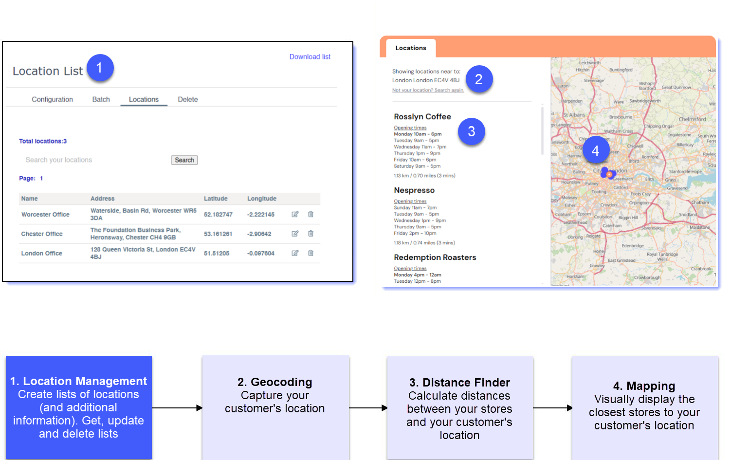
Location Management
The first thing you need to decide where you will host your list of stores or locations that you want your customers to visit. There are three options for doing this:- Upload one or more lists in a CSV format via your account (www.account.loqate.com). This method requires no technical skills, and is generally better for lists that don’t need changing or updating frequently, and that you’re happy to update manually
- Upload one or more lists via the Create List API. This method is generally better if you have a list that requires updating frequently, or you want to programmatically create and edit lists rather than doing this manually
- Host a list yourself or with a third party. If you don’t want to send us your locations, or you already have them stored elsewhere, you can simply pass the co-ordinates of your locations (and any other optional information) to our Distance Finder API later on
It’s crucial that we have co-ordinates for each of your stores, for use later on in the process. If you have addresses but not co-ordinates, don’t worry - we can append them for you when you upload. You can either request this as a parameter when you call the Create List API, or select it as an option in your account.
- Make changes using the Update List or Point API
- Delete lists you don’t want/need any more using the Delete List or Point API
- See the details of all the locations within a list using the Get List API
If you have stores in multiple regions you can either create multiple lists for each region, or combine them into one. Creating multiple smaller lists can be beneficial to improve performance, and help manage different Store Finders for different countries.
Geocoding
Once you have at least one list of your stores, the next thing to do is to identify your customer’s current location. The Global Geocoding API takes a customer’s address, post code or locality (inputted by the customer into an appropriate field on your website), and returns a set of co-ordinates identifying where that location is in the world. You can then take these co-ordinates and pass them into our Distance Finder API in the next step.Distance Finder
At this point in the process you have the locations of each of your stores, and the location of your end user. The next task is to identify which of your stores are closest to your customer, so that you can (in the next step) present the most appropriate options back to them. We can can calculate this for you by passing the following two pieces of information into our Global Distance Finder API:- The co-ordinates of your customer that you received from our Geocoding API
- Either the ID of your Location List, or the locations (via an array including ID, name and lat/long co-ordinates for each) that you have passed to use as part of the API request